
Page 24 - ดาวเทียมอุตุนิยมวิทยา
P. 24
24
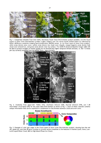
Fig. 1. Comparison between True Color (left), the binary Cloud /Snow Discriminator product (middle), and the Cloud
Layers & Snow Cover Discriminator product (right) imagery over the north-central United States as collected by
NASA’s MODerate-resolution Imaging Spectroradiometer (MODIS) sensor. In the Cloud Layers & Snow Cover product,
white areas denote snow cover, yellow areas denote low cloud cover (liquid), orange/magenta areas denote high
cloud cover (mixed/ice), and green areas denote clear sky surface. The GOES-R Advanced Baseline Imager (ABI) will
be able to produce imagery of similar quality but at dramatically higher temporal refresh (minutes, vs. the 1-2 times
per day currently available from the MODIS Terra + Aqua tandem).
Fig. 2. Clockwise from upper-left: Visible (VIS), shortwave infrared (SIR), thermal infrared (TIR), and 1.38
micrometer cirrus-band (CIR) for the same date/time/domain as shown in Fig. 1. Each of these channels contains
unique information that can be exploited in complement to discriminate between cloud and snow cover.
Fig. 3. Example of color gun usage in the Cloud Layers & Snow Cover Discriminator product, showing how the red
(R), green (G), and blue (B) guns combine to provide various tonalities to the features of interest (Land, Snow, Low-
Level Liquid Water Cloud, Mid-to-High Mixed-Phase/Ice Cloud).