
Page 149 - ภาษาอังกฤษสำหรับสายวิทยาการอุตุนิยมวิทยา
P. 149
144
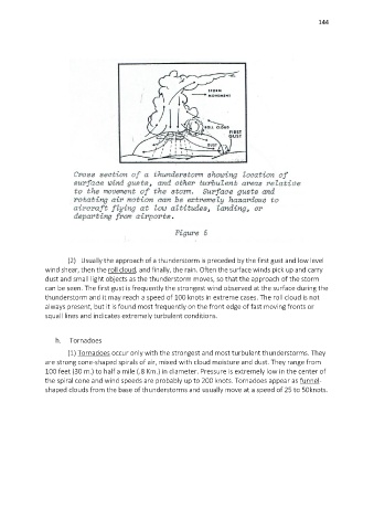
(2) Usually the approach of a thunderstorm is preceded by the first gust and low level
wind shear, then the roll cloud, and finally, the rain. Often the surface winds pick up and carry
dust and small light objects as the thunderstorm moves, so that the approach of the storm
can be seen. The first gust is frequently the strongest wind observed at the surface during the
thunderstorm and it may reach a speed of 100 knots in extreme cases. The roll cloud is not
always present, but it is found most frequently on the front edge of fast moving fronts or
squall lines and indicates extremely turbulent conditions.
h. Tornadoes
(1) Tornadoes occur only with the strongest and most turbulent thunderstorms. They
are strong cone-shaped spirals of air, mixed with cloud moisture and dust. They range from
100 feet (30 m.) to half a mile (.8 Km.) in diameter. Pressure is extremely low in the center of
the spiral cone and wind speeds are probably up to 200 knots. Tornadoes appear as funnel-
shaped clouds from the base of thunderstorms and usually move at a speed of 25 to 50knots.