
Page 63 - AFMAN 15-111, 12 MAR 2019
P. 63
AFMAN15-111 12 MARCH 2019 63
element using one of the following methods. Note: Determining layer height based on the
speed of movement of individual cloud elements is not a reliable method.
11.5.4.1. Deployable meteorological equipment such as an AN/TMQ-53 ceilometer.
11.5.4.2. A handheld ceilometer. When used, this device must be held as perpendicular to
the ground as possible and used only to measure cloud bases directly overhead. If held at
an angle, it erroneously displays heights as too great.
11.5.4.3. PIREPs from aircraft in the local area.
11.5.4.4. Known heights of unobscured portions of natural landmarks or objects.
11.5.4.5. Observation of a weather balloon; dew point depression from upper air profiles.
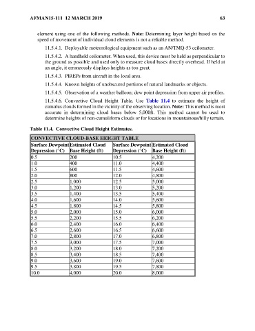
11.5.4.6. Convective Cloud Height Table. Use Table 11.4 to estimate the height of
cumulus clouds formed in the vicinity of the observing location. Note: This method is most
accurate in determining cloud bases below 5,000ft. This method cannot be used to
determine heights of non-cumuliform clouds or for locations in mountainous/hilly terrain.
Table 11.4. Convective Cloud Height Estimates.
CONVECTIVE CLOUD-BASE HEIGHT TABLE
Surface Dewpoint Estimated Cloud Surface Dewpoint Estimated Cloud
Depression (°C) Base Height (ft) Depression (°C) Base Height (ft)
0.5 200 10.5 4,200
1.0 400 11.0 4,400
1.5 600 11.5 4,600
2.0 800 12.0 4,800
2.5 1,000 12.5 5,000
3.0 1,200 13.0 5,200
3.5 1,400 13.5 5,400
4.0 1,600 14.0 5,600
4.5 1,800 14.5 5,800
5.0 2,000 15.0 6,000
5.5 2,200 15.5 6,200
6.0 2,400 16.0 6,400
6.5 2,600 16.5 6,600
7.0 2,800 17.0 6,800
7.5 3,000 17.5 7,000
8.0 3,200 18.0 7,200
8.5 3,400 18.5 7,400
9.0 3,600 19.0 7,600
9.5 3,800 19.5 7,800
10.0 4,000 20.0 8,000